Konya, which hosts tourists from all around the world through cultural tourism, also attracts visitors with its caves.
Tınaz Tepe Cave
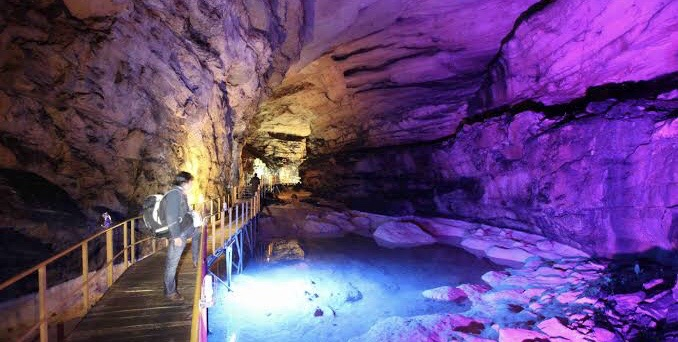
The 22-kilometer-long Tınaztepe Cave, located on the Konya-Antalya highway and discovered by a French scientist in 1968, is described as a "natural wonder".
In the cave, whose navigable section is 1580 meters, the height difference between floor and ceiling reaches 65 meters in some places. The galleries in the cave offer a visual feast to their visitors.
Çamlık Caves
Balatini Cave in the Çamlık Caves region, located within the borders of Konya's Derebucak district and declared as a national park in 2022, can be explored thoroughly. The lighting and furnishing works carried out in order to bring the cave, which has a spectacular structure, into tourism, have come to an end. The steepness of the land in the area where the cave is located creates suitable habitats for wildlife, and protected wild goats can also be seen in the region. There are nearly 20 large and small caves in the surrounding area.
Güvercinlik: 130 meters vertical cave
Güvercinlik Cave, located at an altitude of 1090 meters in Güneybağ District of Güneyşığı district, is located 130 meters underground. It is possible to come across a wide variety of formations such as stalactites, stalagmites and cave milks in the cave, which can be visited by professionals.
Güneysınır Mayor Ahmet Demir stated that “We are working on the cave, which will contribute to our district in cultural terms. Hopefully, we want to make Güvercinlik Cave more visitable. No one except professional cavers can descend because there is a vertical descent of 130 meters. Its floor is approximately the width of a football field. We held meetings with the ministries, projects are being prepared."
Baltaini Cave
It is an active stream cave passing on the right side of the river ledge, which is widely covered with limestone. It is located on the north-facing slope of Uzunsu Valley, above Balat hamlet, and is 6 km away from Derebucak and 5 km from Çamlık District.
Balatini Cave consists of two levels located one above the other. The floor of the fossil arm forming the upper floor is completely covered with cave clay. The main gallery, which is the lower floor and carries water, can be advanced by walking through the water during periods when water is low. Only three potholes, one of which is more than 5 meters deep, can be crossed with passing techniques or by using a boat. Travertines and giant potholes are the beauties of the cave worth seeing. The cave has one entrance and four exits.
Körükini Cave
This cave, formed by the Uzunsu Stream of Derebucak, is 1 km west of Çamlık District and can be reached by a stabilized road. The entrance has an impressive appearance with a height of 30 m, and there are water-eroded rock pieces of equal width in the passage. There is a deep lake at the end of the passes, 130 meters ahead.
As you walk by, larger and more slippery rock pieces appear. The cave ceiling is sometimes meters high. The cave continues in similar styles but has exits exceeding the dimensions of 12x12 meters in diameter. Almost a hundred meters before reaching the exit, you will encounter the truly remarkable view on the right of the passage. This section consists of many pools, stalactites and stalagmites. During the summer months, the pool is not full. The depths of the pools are between half a meter and one and a half meters, and the waters are clear. In this part, there are stalactites formed on the ceiling. These make the cave look more beautiful.
Suluin Cave
There are very large rocks on the polje located between the opposite heights of the Değirmenlik Valley of Derebucak. The upper entrance of the cave is rocky. After passing two ponds after the entrance, you come to the long pond. (150 m) There are 14 cave frescoes with saints and saintess from the Roman period on the walls of the cave.
The width of the cave varies between 3-8 meters, but the height can exceed 20 meters. Deep waters cover the entire expanse of the gorge and can be navigated by a short-oared boat. In some parts, the depth of the water can reach 5 meters. The passage widens further towards the exit. The 10-meter-wide rift, which looks quite spectacular here, is getting wider and wider. Huge expanses have formed around the exit of the cave. There are no visible edges inside the cave. The visitors must have a boat and enter with a boat from the exit. There is access via a stabilized road to the cave exit.
Sakal tutan Cave
You can reach Sakal Tutan Cave, located within the borders of Seydişehir district, at the foot of the Taurus Mountains, which is the Cave Paradise, via Süleymaniye Village on the Mortaş road.
According to the research done in the cave, Sakal Tutan Cave, which is within the vertical cave group and has a depth of 303 meters, ends with a lake. In the cave, which is popularly known as Düden Shroud Threshold, a stream with a very high flow rate occurs in the summer months. The water of the stream originates from the Water Eye located near Değirmenlik Village. The cave, which was first discovered by French cavers, was subjected to extensive research and experiments between 1979 and 1980. The cave, which was mapped in 1979, has not been deeper than 300 meters since then.
Beyşehir Pınarbaşı Cave
Beyşehir Pınarbaşı Cave is located on the southwestern slope of Kızılova Polje, south of Beyşehir Lake. A road branching off from the Beyşehir-Derebucak highway passes through Kızılova Polje and reaches Pınarbaşı Village. The cave is very close to the village. It is a horizontal cave developed on a prominent fault in the Cretaceous limestone. The cave, from which a large karst spring emerges, contains siphuncles and lakes that are difficult to pass through. For this reason, it is a difficult cave to explore. It is also extremely rich in terms of dripstone accumulation.
Within the scope of the "Cave Tourism Project" of the Ministry of Culture and Tourism, 50 of the more than 20 thousand caves in the country have been opened to tourism so far.